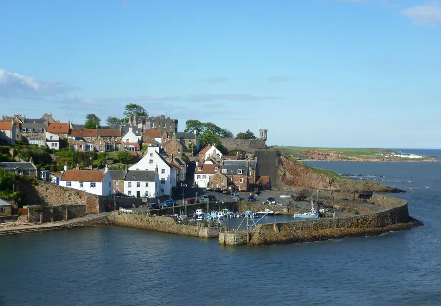
Crail is a coastal village and royal burgh in the East Neuk of Fife, with an estimated population of 1,630 in 2018. What it has kept is a working harbour, a market square with a mercat cross at its centre, and a beach beside the harbour with fossilised trees in it.
Those trees are the thing here that no other East Neuk village offers: they lie on the shore beside the harbour walls, they are related to horsetails, and they date to the Carboniferous period. The other reason to make the trip is the burgh itself, made a royal burgh in 1178 during the reign of William the Lion, with Robert the Bruce later granting it permission to hold markets on a Sunday.
The straight-line distance from St Andrews is 13.6 km.
The harbour carries 4.7 from 1,221 Google reviews, the largest sample of anything in the village, and it is still in use. A visitor in June 2026 wrote, “Lovely old harbour. Not been here in many years. Still a working harbour, which is good.”
Its two piers have separate stories. The eastern pier was described in 1610 as “new foundit” — newly built — but by 1707 it was called “old and ruinous” and needed rebuilding. The west pier was rebuilt in 1828 by Robert Stevenson, and that work incorporated the crane on the south-west corner, which lifts timbers into slots to seal the inner harbour. The inner walls repay a look on their own account: the stones are laid in a highly unusual vertical coursing.
Beside the harbour is the beach, listed as Crail Beach at 4.8 from 23 Google reviews — too small a sample to weigh heavily — with the fossils listed separately as Crail Beach Fossils, 4.7 from 82 Google reviews. A visitor in August 2026 wrote, “Nice beach at the harbour,” and mentioned a book cupboard there where children could pick up a bucket, and an ice cream shop around the corner.
The centre of the town is the Marketgate, a large marketplace with the mercat cross in the middle, where the Sunday markets were once held. It is now used as a car park. The tolbooth stands on its own at the edge of it, near the junction of Tolbooth Wynd and the Marketgate, its tower dating from about 1600 and its roof a European style similar to buildings in Holland. The weathervane on the spire is not the usual cockerel but a smoked haddock, known locally as a Crail Capon.
The parish church in the Marketgate is the most notable building in the town, founded in the second half of the 12th century and dedicated in the 13th to St Maelrubha of Applecross. An 8th-century cross-slab preserved inside shows the site had religious associations before the church was founded; it belonged to the Cistercian Nunnery of St Clare in Haddington until the Reformation, and the kirkyard includes a war memorial gateway of 1921.
At the top of Tolbooth Wynd is the Crail Museum and Heritage Centre, largely staffed by volunteers and a summer proposition rather than a year-round one, with temporary exhibitions and a permanent one on RNAS Crail.
Crail Pottery is the highest-rated thing listed in the village, 4.8 from 188 Google reviews — a family-run pottery and ceramics workshop and shop founded in 1965 by Stephen and Carol Grieve. The making happens on site: a visitor in June 2026 wrote, “Beautiful hand made pottery, it’s good to see it being made aswell.”
The Crail Harbour Gallery and Tearoom carries 4.6 from 1,120 Google reviews, and those reviews split. A visitor in July 2026 wrote, “Lovely place, basic menu but given the size that makes sense. Great view and lovely vibes.” A visitor in August 2026 left one star and began, “Such a disappointment. We arrived with two dogs and were initially welcomed.” Both are consistent with a small place under pressure in season.
Golf is the other draw. The Crail Golfing Society, formed in 1766, is the seventh-oldest in the world, and its oldest course, Balcomie, was laid out by Tom Morris Sr in 1894, though competitions had been played there since the 1850s. It carries 4.7 from 419 Google reviews, and not every round goes well — a visitor in June 2026 wrote, “True links course spoiled by being too busy with a lot of over ambitious golfers playing of inappropriate tees.”
Caiplie Caves, a historical landmark at 4.6 from 168 Google reviews, is listed among the village’s attractions with nothing in the encyclopaedia entry to explain it.
The burgh’s history keeps touching St Andrews. Mary of Guise, later consort of James V, landed at Crail in June 1538 after a severe storm, was entertained at Balcomie Castle and travelled on to St Andrews with the king. John Knox, passing through on his way to St Andrews in 1559, was moved to preach in the parish church; afterwards protesters went through it and forcibly removed images put there by earlier generations.
The fishing here was not the same trade as at Anstruther and Pittenweem — more local fishing, with an emphasis on shellfish — and the port went on prospering up to the First World War. The Royal Burgh of Crail Council was abolished in 1976 and the burgh arms went with it; in 2017 the community council was granted Letters Patent to the Crail Shield and Coat of Arms. The names the village counts as its own include James Sharp, who became Archbishop of St Andrews, the cryptanalyst Joan Clarke and the singer-songwriter King Creosote.
One bus does it. Stagecoach East Scotland service 95 runs from Leven to St Andrews by way of Pittenweem and Anstruther, and it is the only bus service that serves Crail; it is hourly and runs every day. That makes the village reachable without a car, and it also means a missed bus is an hour.
There is no railway. St Andrews has no station of its own either — the station for the town is Leuchars, in the other direction entirely — and beyond service 95 the research pack establishes no rail or bus link between the two.
The village and what is around it, at walking scale.
Open any of them in Google Maps for directions and current opening.
Attractions, prices and availability in St Andrews
These come from GetYourGuide's booking widget, which sets their cookies in your browser. Consent to load it and see the attractions and prices.
Background on Crail draws on its Wikipedia article, text there being available under CC BY-SA 4.0.